Lake levels hero

Lake Levels

At Meridian, we manage around half of New Zealand's total hydro storage.

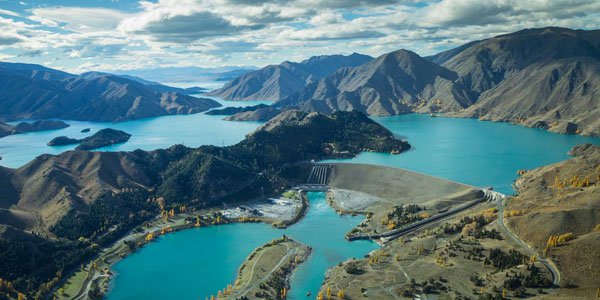
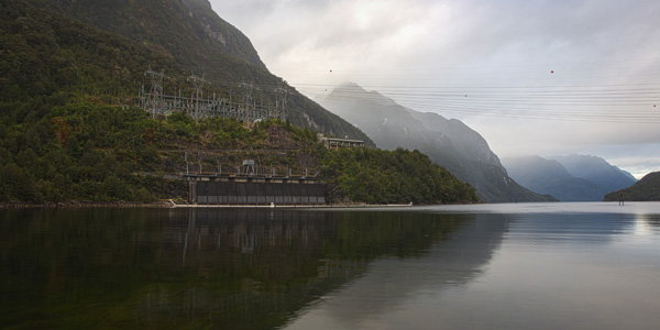
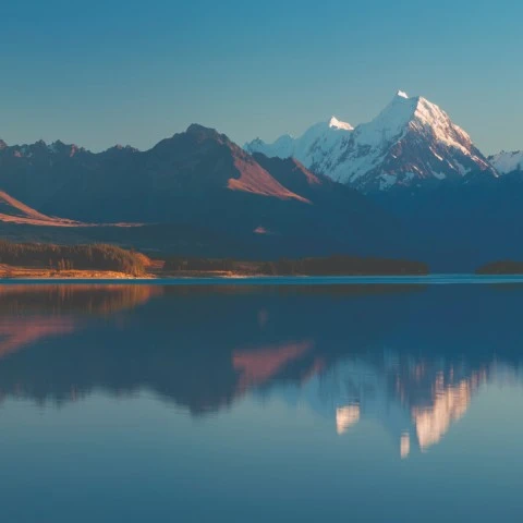
We operate six power stations in the Waitaki hydro scheme and the country's largest hydro station Manapōuri.

Below you’ll find information on the dimensions of each of the lakes we use to generate energy (Pūkaki, Ōhau, Aviemore, Waitaki, Benmore, Manapōuri and Te Anau) and recent lake level and river flow data.

Lake dimensions

These are the dimensions of the different lakes noted below.


 Lake

Lake area
(at normal maximum control level)

Average lake level
(above sea level)

Te Anau 352  
Manapōuri 141 177.7
Pūkaki 179.5 527.7
Ruataniwha 4.9 458.7
Ōhau 61.2 519.8
Benmore 74.5 361.1
Aviemore 28.8 268.1
Waitaki 6.2 230.2

Lake levels and river flows

Waitaki hydro scheme

The Waitaki hydro scheme includes eight power stations from Lake Tekapo to Lake Waitaki. Meridian operates stations at Lake Ōhau, Benmore, Aviemore and Waitaki, and Genesis Energy operates the two stations linked by the Tekapo canal.

Meridian Waitaki hydro

Lake Pūkaki lake levels

The measurements are shown in metres above sea level. The minimum consented level of Lake Pūkaki is 518.0m. Levels above 532.5m are subject to minimum outflow requirements.

These levels shown are provisional and are indicative only and for general information purposes, and do not try to show what actual levels will be at any particular time or place. If you intend to use the hydro lakes for any recreational or other purpose, please ensure that your activity can be safely carried out if the actual water levels change.

Pūkaki river flow

Measurements shown are in cubic metres per second.

The Pukaki spillway discharges into the Pukaki River and joins the Tekapo River before flowing into Lake Benmore.

Flows shown are provisional and are indicative only for general information purposes and do not try to show what actual flow will be at any particular time or place. If you intend to use the Pukaki River for any recreational or other purpose, please ensure that your activity can be safely carried out if the flow changes.

Lake Ōhau lake levels

The measurements are shown in metres above sea level. The minimum consented level of Lake Ōhau is 519.45m. Levels above 520.4m result in water discharging over the outlet weir and into the Upper Ōhau River. Levels above 520.25m are subject to minimum outflow requirements via the Ōhau Canal.

These levels shown are provisional and are indicative only and for general information purposes, and do not try to show what actual levels will be at any particular time or place. If you intend to use the hydro lakes for any recreational or other purpose, please ensure that your activity can be safely carried out if the actual water levels change.

Upper Ōhau river flow

Measurements shown are in cubic metres per second.

The Upper Ōhau River flows from Lake Ōhau to Lake Ruataniwha.

Flows shown are provisional and are indicative only for general information purposes and do not try to show what actual flow will be at any particular time or place. If you intend to use the Upper Ōhau River for any recreational or other purpose, please ensure that your activity can be safely carried out if the flow changes.

Data curtesy of Environment Canterbury.

Ruataniwha Spillway Flow

Measurements shown are in cubic metres per second.

The Ruataniway spillway discharges into the Lower Ōhau River which flows into Lake Benmore.

Flows shown are provisional and are indicative only for general information purposes and do not try to show what actual flow will be at any particular time or place. If you intend to use the Waitaki River below Benmore Dam for any recreational or other purpose, please ensure that your activity can be safely carried out if the flow changes.

Lake Benmore lake levels

The measurements are shown in metres above sea level. The minimum consented level of Lake Benmore is 355.25m. Levels above 361.45m are subject to minimum outflow requirements.

These levels shown are provisional and are indicative only and for general information purposes, and do not try to show what actual levels will be at any particular time or place. If you intend to use the hydro lakes for any recreational or other purpose, please ensure that your activity can be safely carried out if the actual water levels change.

Benmore Spillway Flow

Measurements shown are in cubic metres per second.

Flows shown are provisional and are indicative only for general information purposes and do not try to show what actual flow will be at any particular time or place. If you intend to use the Waitaki River below Benmore Dam for any recreational or other purpose, please ensure that your activity can be safely carried out if the flow changes.

Lake Aviemore lake levels

The measurements are shown in metres above sea level. The minimum consented level of Lake Aviemore is 265.5m. Levels above 268.3m are subject to minimum outflow requirements.

These levels shown are provisional and are indicative only and for general information purposes, and do not try to show what actual levels will be at any particular time or place. If you intend to use the hydro lakes for any recreational or other purpose, please ensure that your activity can be safely carried out if the actual water levels change.

Aviemore spillway flow

Measurements shown are in cubic metres per second.

Flows shown are provisional and are indicative only for general information purposes and do not try to show what actual flow will be at any particular time or place. If you intend to use the Waitaki River below Aviemore Dam for any recreational or other purpose, please ensure that your activity can be safely carried out if the flow changes.

Lake Waitaki lake levels

The measurements are shown in metres above sea level. The minimum consented level of Lake Waitaki is 227.0m. Levels above 230.8m result in water discharging over the concrete weir.

These levels shown are provisional and are indicative only and for general information purposes, and do not try to show what actual levels will be at any particular time or place. If you intend to use the hydro lakes for any recreational or other purpose, please ensure that your activity can be safely carried out if the actual water levels change.

Waitaki spill weir flow

Measurements shown are in cubic metres per second.

When the level of Lake Waitaki exceeds 230.82m, water flows over the Spill Weir.

Flows shown are provisional and are indicative only for general information purposes and do not try to show what actual flow will be at any particular time or place. If you intend to use the Waitaki River below Waitaki Dam for any recreational or other purpose, please ensure that your activity can be safely carried out if the flow changes.

Manapōuri power station

The Manapōuri power station is New Zealand's largest hydro station. Situated in Fiordland, the catchment area of Lakes Te Anau and Manapōuri receives some of New Zealand's highest rainfall. These two lakes are linked by a river system, providing water for generation at Manapōuri.

Meridian Manapouri hydro station

Lake Te Anau lake levels

The measurements are shown in metres above sea level. The main operating range for Lake Te Anau (as defined by the Lake Level Guidelines 2002) is between 201.5 and 202.7 metres above sea level. Operation outside this range is allowable in compliance with the guidelines.

These levels shown are provisional and are indicative only and for general information purposes, and do not try to show what actual levels will be at any particular time or place. If you intend to use the hydro lakes for any recreational or other purpose, please ensure that your activity can be safely carried out if the actual water levels change.

Upper Waiau river flow

Measurements shown are in cubic metres per second.

The Upper Waiau River flows from the Te Anau Lake Control gates to Lake Manapōuri.

Flows shown are provisional and are indicative only for general information purposes and do not try to show what actual flow will be at any particular time or place. If you intend to use the Upper Waiau river for any recreational or other purpose, please ensure that your activity can be safely carried out if the flow changes.

Lake Manapōuri lake levels

The measurements are shown in metres above sea level. The main operating range for Lake Manapōuri (as defined by the Lake Level Guidelines 2002) is between 176.8 and 178.6 metres above sea level. Operation outside this range is allowable in compliance with the guidelines.

These levels shown are provisional and are indicative only and for general information purposes, and do not try to show what actual levels will be at any particular time or place. If you intend to use the hydro lakes for any recreational or other purpose, please ensure that your activity can be safely carried out if the actual water levels change.

Lower Waiau river flow

Measurements shown are in cubic metres per second.

The Lower Waiau River flows from Manapōuri Lake Control gates.

Flows shown are provisional and are indicative only for general information purposes and do not try to show what actual flow will be at any particular time or place. If you intend to use the Lower Waiau River for any recreational or other purpose, please ensure that your activity can be safely carried out if the flow changes.

Current snow storage

We also collect information on the amount of water stored as snow so we can estimate its impact on inflows.

See current snow storage